


The Science and Causes Behind Sea-Level Rise and Coastal Erosion
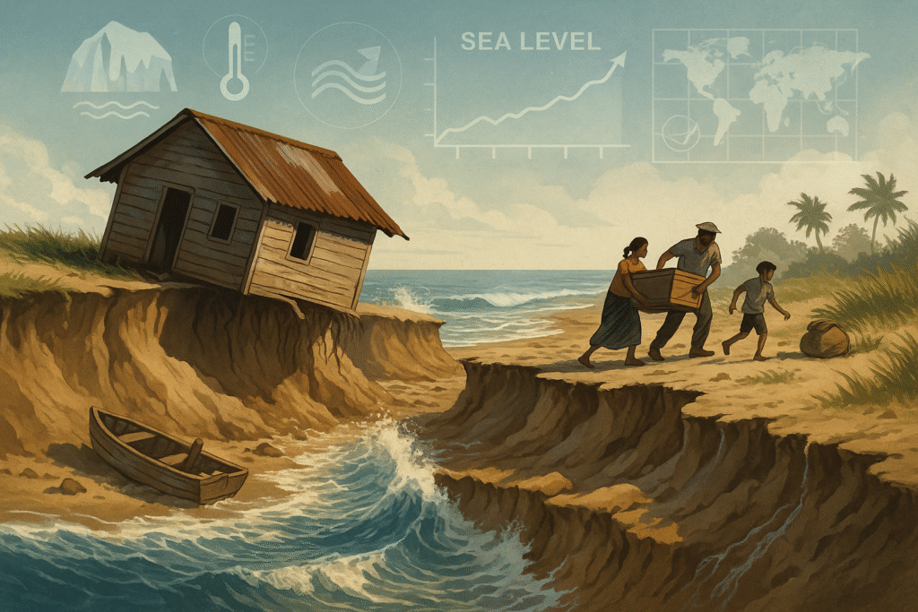
Sea-level rise and coastal erosion are the result of interconnected oceanic, atmospheric, and geological processes. Although these two phenomena are often discussed together, each has its own scientific foundations and mechanisms. Understanding these processes is essential for designing effective adaptation strategies and for recognizing why certain coastlines are changing more rapidly than others. This section explains the science in clear, accessible language so that readers can interpret data and real-world impacts with greater clarity.
1. Why Is Global Sea Level Rising?
Global sea level is rising primarily because the Earth is warming. This warming affects oceans, glaciers, and the atmosphere in measurable ways. Scientists identify two dominant contributors to sea-level rise:
1.1 Melting of Glaciers and Ice Sheets
As global temperatures rise, mountain glaciers, polar ice sheets, and permafrost regions continue to lose mass. When land ice melts, the resulting water flows into the ocean and increases total ocean volume. Ice loss from Greenland and Antarctica has accelerated in recent decades, contributing significantly to global sea-level rise. This process is particularly concerning because once ice-sheet destabilization begins, it can continue for centuries, even if temperatures stabilize.

1.2 Thermal Expansion of Ocean Water
Oceans absorb over 90% of the excess heat trapped by greenhouse gases. As seawater warms, it expands—this is known as thermal expansion. No new water is added to the oceans in this process; rather, existing water increases in volume simply because it becomes warmer. Scientists estimate that nearly half of observed sea-level rise over the last century is due to this expansion alone, making it one of the most important physical drivers.
2. What Is Coastal Erosion and Why Is It Increasing?
Coastal erosion refers to the gradual loss or retreat of land along coastlines due to the action of waves, currents, tides, and storms. Although erosion is a natural process, it has intensified due to climate change and human activities.
2.1 Stronger Waves, Storm Surges, and Extreme Events
As sea level rises, waves reach farther inland and with greater force. Climate change also influences storm frequency and intensity, leading to more damaging cyclones, hurricanes, and storm surges. Higher base sea levels amplify these impacts, making each event more destructive than it would have been in the past. Wave energy plays a crucial role in shaping coastlines, and as that energy increases, erosion accelerates.
2.2 Human Interventions and Coastal Engineering
Harbor construction, seawalls, jetties, sand mining, and river damming disrupt the natural movement of sediment along coastlines. Beaches and dunes depend on a continuous supply of sediments to maintain their structure. When this supply is blocked or reduced—a condition known as “sediment starvation”—coasts become unstable and erode faster. Poorly planned infrastructure often magnifies the problem by altering natural water flow and wave patterns.
2.3 Land Subsidence and Groundwater Extraction
In some regions, the land itself is sinking due to groundwater extraction, mining activities, soil compaction, or geological processes. When land subsidence combines with rising seas, the relative sea-level rise becomes much greater, exposing communities to severe erosion, flooding, and saltwater intrusion. Many delta regions around the world face this dual threat.
3. How Climate Change Links Both Processes
Climate change amplifies both sea-level rise and erosion. Warmer oceans expand, storms become more intense, and ice loss accelerates. Higher sea levels allow waves to penetrate farther inland, while changing storm tracks and monsoon systems increase the unpredictability and severity of erosion events. The two processes feed into each other: rising seas create more erosion, and eroded coastlines become more vulnerable to flooding.
4. Impacts on Coastal Ecosystems
Mangroves, coral reefs, coastal wetlands, and barrier dunes act as natural buffers that protect inland areas from storms and waves. Rising seas drown wetlands and reduce the area available for mangroves to grow if they are blocked by human development. Coral reefs suffer from warming waters and acidification, limiting their ability to regenerate and provide natural wave protection. When ecosystems deteriorate, coastlines face erosion at an even faster pace.
5. Why the Problem Is Accelerating
The rapid pace of change is the result of an overlap between natural processes and human-driven pressures. Rising global temperatures, increasing storm intensity, rapid coastal development, and the destruction of natural protective systems all contribute to faster and more widespread erosion. What might once have taken centuries is now happening within decades—or even years.
Understanding the science and underlying causes is crucial for shaping future decisions on coastal planning, adaptation strategies, and community resilience. In the next section, we will examine the environmental, social, and economic impacts that arise from these scientific processes and explore how they are reshaping coastlines around the world.

Impacts of Sea-Level Rise and Coastal Erosion in India and Key Case Studies
India’s coastline spans more than 7,500 km, supporting millions of people, diverse ecosystems, major ports, and rapidly growing coastal cities. However, rising sea levels and accelerating coastal erosion are placing this vast stretch under severe and persistent stress. The combined effects are visible in eroding beaches, shrinking villages, disrupted livelihoods, and repeated flooding in many urban and rural areas. This section explains the major impacts of sea-level rise in India and presents detailed case studies that reveal the scale and human dimension of the crisis.
1. Major Impacts on India’s Coastal Regions

1.1 Threat to Livelihoods
Millions of people living along India's coasts depend on fishing, aquaculture, tourism, port-related jobs, and coastal agriculture. With rapid shoreline retreat, fishing harbors are becoming unstable, traditional landing points are disappearing, and houses near the coast are collapsing or being abandoned. In several states, fishermen report that they now must travel farther into the sea due to changing fish patterns, increasing fuel costs and reducing daily income.
1.2 Increased Flooding in Coastal Cities
Major coastal cities—Mumbai, Chennai, Kolkata, Kochi, and Visakhapatnam—face repeated flooding due to rising sea levels combined with heavy rainfall, clogged drainage, and urban sprawl. Low-elevation neighborhoods get inundated during high-tide events, and storm surges now travel deeper inland. Chennai’s 2015 flood, Mumbai’s repeated monsoon flooding, and Kochi’s recurrent tidal inundation highlight the growing vulnerability of urban centers.
1.3 Damage to Agriculture and Drinking Water
Saltwater intrusion is degrading vast areas of coastal farmland. Rice paddies, coconut plantations, banana fields, and vegetable gardens have suffered declining productivity in parts of Odisha, Tamil Nadu, West Bengal, and Gujarat. Groundwater aquifers—critical for drinking water—are turning saline, forcing communities to depend on external water supply or migrate to safer areas.
1.4 Loss of Coastal Ecosystems
Mangroves, coral reefs, coastal wetlands, mudflats, and dunes—India’s natural protective barriers—are shrinking rapidly. The Sundarbans mangrove delta is experiencing severe erosion, while coral bleaching in the Andaman–Nicobar and Lakshadweep islands is reducing natural wave protection. Ecosystem loss weakens coastal resilience and increases the pace of further erosion.
2. Major Case Studies from Across India
2.1 Case Study: Kerala — Severe Erosion in Alappuzha and Ernakulam
Kerala has emerged as one of India’s worst-affected states in terms of coastal erosion. In Alappuzha and Ernakulam districts, beaches are retreating by several meters annually. Houses have collapsed into the sea, schools have been relocated, and fishing communities frequently shift their settlements. Although sea walls and groynes have been constructed, experts argue that these only shift erosion to neighboring areas.
As a response, Kerala has adopted eco-restoration approaches such as beach nourishment, dune rehabilitation, and mangrove planting. Community participation has become essential in managing erosion hotspots.
2.2 Case Study: Odisha — Gopalpur to Chandipur Region
Odisha’s coastline, especially around Gopalpur, Puri, and Chandipur, has witnessed significant land loss due to rising seas and powerful cyclones. Villages such as Satabhaya have been displaced multiple times, with families losing both farmland and homes. Cyclones like Phailin, Fani, and Amphan have reshaped large stretches of the coast.
Odisha’s strong disaster-management framework—early warning systems, cyclone shelters, and community mapping—offers a successful model for other states to follow.
2.3 Case Study: West Bengal — The Shrinking Sundarbans
The Sundarbans delta, shared by India and Bangladesh, is one of the most threatened coastal ecosystems in the world. Rising sea levels, embankment breaches, and stronger cyclones have led to dramatic island shrinkage. Islands such as Ghoramara and Lohachara have lost major portions of land, forcing thousands of people to migrate.
Loss of mangroves reduces natural protection, leaving villages exposed to storm surges. Researchers warn that continued degradation could submerge significant parts of the Sundarbans within the next few decades.
2.4 Case Study: Gujarat — Kutch and Saurashtra Coasts
Gujarat’s coastline is experiencing rapid erosion due to industrial expansion, port construction, changing sediment patterns, and natural shifts in wind and wave regimes. Areas near Porbandar, Veraval, and Dahej show significant beach narrowing, threatening both fishing settlements and industrial installations.
Some regions have started experimenting with artificial reefs, mangrove afforestation, and wave-breaker blocks. Early studies show that these measures are reducing wave energy and stabilizing portions of the shoreline.
2.5 Case Study: Tamil Nadu — Chennai and Cuddalore
Chennai, one of India’s largest coastal cities, faces rising sea levels, rapid urbanization, and more frequent storm surges. Combined with poor drainage, these factors create annual flooding in low-lying areas. The stretch between Adyar and Ennore has undergone intense erosion due to industrial structures and breakwaters altering sediment flow.
In Cuddalore and Nagapattinam, entire fishing villages have been displaced due to land loss. Roads, schools, temples, and coastal landmarks have been damaged by waves repeatedly hitting the shore.
3. Why India’s Coastal Risk Is Higher
- Large population living in low-elevation coastal zones
- Rapid coastal development and industrial expansion
- Increasing frequency and intensity of cyclones
- High dependence on coastal agriculture and fisheries
- Degradation of natural shoreline protections
These overlapping pressures make India one of the most vulnerable countries to sea-level rise and coastal erosion. The physical changes are fast, the economic impacts are large, and the human costs are profound.

Solutions and Policy: Coastal Protection, Adaptation, and Long-Term Strategies
Addressing sea-level rise and coastal erosion requires a multi-layered approach that blends engineering, ecosystem restoration, community participation, and strong policymaking. India’s diverse coastline means that no single solution can work everywhere. Effective adaptation emerges only when scientific understanding, local needs, and long-term planning come together. In this section, we explore hard engineering measures, nature-based solutions, technological innovations, and policy frameworks that together create a resilient coastal future.
1. Hard Engineering Solutions
Hard engineering uses physical structures to protect coastlines from waves, storm surges, and erosion. These measures often provide immediate relief but can have ecological side effects if not designed carefully.
1.1 Sea Walls
Sea walls are constructed along the shore to absorb wave impact and shield inland areas. They are effective in protecting roads, buildings, and essential infrastructure. However, poorly designed sea walls can reflect wave energy, increasing erosion in nearby regions. Maintenance costs also tend to rise over time as sea levels continue to increase.

1.2 Groynes and Breakwaters
Groynes are structures placed perpendicular to the shore to trap sand and stabilize beaches. Breakwaters are built offshore to reduce wave energy before it reaches the shore. Both can slow erosion, but they may alter natural sediment movement, requiring careful planning and monitoring.
1.3 Revetments and Geotextile Solutions
Rock revetments, geotextile bags, and armor blocks help protect coastlines from wave action. They serve as flexible barriers and are often used where rapid erosion threatens settlements. While effective in the short term, they need regular inspection and reinforcement.
2. Nature-Based (Soft) Solutions
Nature-based solutions are sustainable, cost-effective, and environmentally friendly. They restore natural systems that act as buffers against storms, waves, and erosion.
2.1 Mangrove Restoration
Mangroves reduce wave energy, stabilize coastlines, and support marine biodiversity. In regions such as the Sundarbans, Gujarat, Maharashtra, and Odisha, mangrove restoration projects have shown measurable success. Healthy mangroves can reduce storm surge intensity by up to 60–80% and offer long-term, low-maintenance protection.
2.2 Beach Nourishment and Dune Restoration
Beach nourishment involves adding sand to eroded beaches to rebuild their natural width. Dune restoration uses vegetation and sand fencing to recreate natural dunes that protect coastal land from storms. These methods maintain natural aesthetics and support ecological balance while reducing erosion risks.
2.3 Coral Reef and Seagrass Conservation
Coral reefs act as natural breakwaters by absorbing wave energy. Seagrass beds stabilize sediments and support marine life. Conservation programs in the Andaman–Nicobar and Lakshadweep islands are restoring these ecosystems through coral gardening, artificial reef structures, and marine protected areas.
3. Community-Based and Technological Innovations
3.1 Early Warning Systems
Modern forecasting tools—radar systems, coastal sensors, satellite data, and mobile alerts—help predict cyclones, high tides, and storm surges. These systems have significantly reduced disaster-related casualties in India by enabling timely evacuation and response.
3.2 Community Participation and Blue Economy Practices
Local communities play a crucial role in sustainable coastal management. Beach clean-up programs, mangrove planting drives, anti-plastic campaigns, and eco-tourism initiatives strengthen public involvement. Blue Economy models encourage communities to balance livelihood activities with ecological responsibility.
3.3 GIS-Based Coastal Planning
GIS, remote sensing, and Earth Engine tools enable accurate mapping of erosion hotspots, flood-prone zones, and future sea-level scenarios. Governments use these datasets to redesign infrastructure, relocate vulnerable settlements, and create coastal master plans.
4. Policy Framework and Governance
Strong policy frameworks guide long-term coastal resilience. India has implemented several regulations and mission-based programs that focus on conservation, risk reduction, and sustainable development.
4.1 Coastal Regulation Zone (CRZ) Norms
CRZ regulations control construction and industrial activities along coastlines. They protect mangroves, dunes, wetlands, and ecologically sensitive areas from unregulated development. Effective enforcement of CRZ norms is essential to prevent long-term erosion.
4.2 National Centre for Coastal Research (NCCR)
NCCR monitors shoreline changes, sea-level variations, and water quality across India. Its scientific reports guide state governments in designing engineering structures, drafting local policies, and prioritizing high-risk zones.
4.3 Managed Retreat and Rehabilitation
In areas where erosion is too severe or sea-level rise is unavoidable, planned relocation becomes necessary. States such as Odisha and West Bengal have already adopted managed retreat strategies, relocating villages that face repeated flooding and land loss.
4.4 International Collaboration and Climate Finance
India participates in global initiatives such as the Paris Agreement, Blue Economy Framework, and disaster-risk reduction platforms. These partnerships support technology transfer, coastal restoration funding, and climate adaptation research.
Ultimately, the most effective strategy combines natural protection, engineering innovation, strong community engagement, and forward-looking policy. These pillars, when integrated, can safeguard India’s coastlines for generations to come. In the next section, we will explore global case studies—both successful and unsuccessful—that offer valuable lessons for India’s long-term coastal resilience.
