Introduction: The Brahmaputra River System – A Journey of Nature, Life and Learning
The Brahmaputra River is not just a geographical feature; it is a living force that represents life, struggles, transformation, and the continuous flow of progress. My fascination with this mighty river began during my school days when I first read about it in geography books. Over time, this curiosity turned into admiration as I understood how the Brahmaputra shapes the culture, climate, biodiversity, and livelihoods of millions across three countries.
In this article, I share my personal perspective, experiences, and learnings while explaining the complete Brahmaputra River System — its origin, course, tributaries, floods, valley formation, biodiversity and environmental challenges. This is not just a collection of facts, but an inspiring journey that reflects how a river teaches us resilience, balance, and the art of moving forward in life.
Example Product Title
👉 Buy on AmazonDisclosure: As an Amazon Associate, I earn from qualifying purchases.
From Childhood Books to the Real River
My first connection with the Brahmaputra River was not through a journey, but through the pages of my school geography books. Back then, it appeared to be just another long blue line on the map — starting from the snowy mountains, flowing across different regions, and finally merging into the vast plains. As a child, I could never grasp the true power, depth, and cultural significance that this river holds. For me, it was simply a chapter to memorize, a diagram to label, and a name to remember for exams.
But as I grew older, my perception began to change. Through documentaries, photographs, and news stories, I witnessed the Brahmaputra not as a static line on paper, but as a living, breathing force. Its massive waves, mighty floods, fertile plains, and the lives connected to its flow revealed a river far more dynamic and powerful than I had ever imagined. The calm images from my childhood textbooks were suddenly replaced by real visuals of a river that could both nurture and challenge the land it touched.
That transition — from reading about the Brahmaputra in books to understanding its true essence — taught me an important lesson: some things cannot be fully understood until they are felt. The Brahmaputra is one such river. To truly know it, one must go beyond facts and figures, and sense the heartbeat of its flow, its strength, and its timeless journey across civilizations.
Brief Introduction to the Brahmaputra River System
Origin, Names and Identity in Different Countries
The Brahmaputra River is one of the most remarkable transboundary rivers of South Asia. Its journey begins in the high and cold regions of Tibet, on the northern slopes of the Himalayas, near the Chema-Yung-Dung area. In this region, the river is known as Yarlung Tsangpo. Here it flows eastward through deep valleys and high plateaus, appearing as a long, narrow and swift mountain river.
After flowing for a considerable distance in Tibet, the river takes a dramatic U-shaped bend, turns towards the south and enters India through the state of Arunachal Pradesh. In this hilly terrain, it is first known as Siang, and then as Dihang (or Dihang/Siang). As it descends from the mountains and gradually approaches the plains, its volume of water increases and the river starts widening.
Further west, when this river enters the plains of Assam, it finally receives its most famous name – Brahmaputra. The entire Brahmaputra Valley of Assam is shaped around this mighty river, which supports agriculture, transport, fisheries and the overall livelihood of millions of people. Moving downstream, the river crosses into Bangladesh, where it is known as Jamuna. Here it flows as a major channel of the Ganga–Brahmaputra–Meghna system and helps in forming one of the largest river deltas in the world. Thus, the same river is identified as Yarlung Tsangpo in Tibet, Siang/Dihang in Arunachal Pradesh, Brahmaputra in Assam and Jamuna in Bangladesh, reflecting its international character and cultural significance.
Length, Drainage Basin and Key Characteristics
The Brahmaputra River is counted among the major rivers of the world in terms of both length and water volume. Its total length is approximately 2,900 kilometres, covering three countries – China (Tibet), India and Bangladesh. During this long journey, the river passes through a variety of landscapes, from high mountain plateaus and deep gorges to wide alluvial plains and low-lying deltaic regions.
The drainage basin of the Brahmaputra is also very extensive. It is estimated to cover around 580,000 square kilometres. This large basin includes Himalayan glaciers, snowfields, plateaus, dense forests, fertile plains and densely populated agricultural areas. Because of this, the Brahmaputra River System is directly linked with the lives, economies and ecosystems of millions of people living in its catchment.
One of the most striking features of the Brahmaputra is its very high water discharge and its flood-prone nature. During the monsoon season, heavy rainfall combined with snowmelt in the Himalayas leads to a rapid rise in the water level, especially in the Assam Valley. In many stretches of its course in Assam, the river flows in the form of braided channels, creating numerous sandbars and river islands, the most famous being Majuli. Almost every year, floods in the Brahmaputra cause significant damage to crops, houses, roads and other infrastructure. At the same time, these very floods deposit rich alluvial soil on the farmlands, making the region highly fertile. Because of this dual nature – destructive and life-giving – the Brahmaputra is often seen as both a powerful challenge and a vital lifeline for the people living along its banks.
Example Product Title
👉 Buy on AmazonDisclosure: As an Amazon Associate, I earn from qualifying purchases.
Tributaries of the Brahmaputra – Major Northern and Southern Bank Rivers
Major Tributaries on the Northern Bank
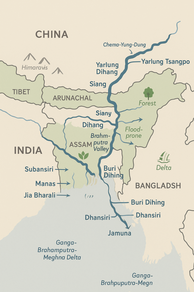
Siang / Dihang
Siang/Dihang is often considered the principal upper course of the Brahmaputra River. After flowing as Yarlung Tsangpo across the Tibetan plateau, the river takes a steep bend and enters India through Arunachal Pradesh, where it is known as the Siang or Dihang. In this region, it flows through deep gorges, steep slopes and thick forests, carrying a large volume of water and sediments.
As the Siang/Dihang moves southward from the mountains towards the plains, its gradient gradually decreases and the river begins to widen. Along its course, it is joined by several smaller streams and rivulets, which increase its discharge. When it finally reaches the plains of Assam, it combines with other tributaries and is widely recognized as the mighty Brahmaputra.
- Source: Enters India from Tibet as the continuation of Yarlung Tsangpo.
- Confluence: Forms the main channel of the Brahmaputra in Assam after joining with other rivers.
- Importance: Major mountain-fed course; crucial for regional climate, forests and local communities.
Subansiri
Subansiri is one of the most important northern-bank tributaries of the Brahmaputra. It originates in the mountainous regions of Arunachal Pradesh and initially flows as a swift and narrow river through rugged terrain. The name “Subansiri” is often associated with the presence of minerals and the golden hue of its sediments in certain stretches.
When Subansiri enters Assam, its channel becomes wider and its flow more regulated. The river supports irrigation, fishing and local transport in the surrounding areas. In recent times, it has also gained prominence due to hydropower projects planned or developed on its course. Eventually, Subansiri joins the Brahmaputra on its northern bank, contributing significantly to its water volume.
- Source: Mountainous areas of Arunachal Pradesh.
- Confluence: Joins the Brahmaputra on the northern bank in Assam.
- Importance: Vital for irrigation, fisheries and hydropower development.
Manas
The Manas River is another major northern-bank tributary of the Brahmaputra, shared between Bhutan and India. It rises in the high mountains of Bhutan and flows through dense forests, steep valleys and wildlife-rich landscapes. The river plays a central role in shaping the ecology of the region before entering the Indian state of Assam.
In Assam, the Manas River flows through and around the famous Manas National Park, which is a UNESCO World Heritage Site and an important tiger and elephant reserve. The river sustains the rich biodiversity of the park and supports agriculture, drinking water and livelihood needs of nearby villages. Finally, the Manas merges with the Brahmaputra on its northern bank, becoming part of the larger river system.
- Source: Mountainous regions of Bhutan.
- Confluence: Meets the Brahmaputra in Assam on the northern bank.
- Importance: Lifeline of Manas National Park; crucial for biodiversity and local communities.
Other Rivers: Jia Bharali, Sankosh and Others
Apart from the major tributaries like Siang/Dihang, Subansiri and Manas, several other rivers from the north join the Brahmaputra and enrich its flow. Among these, Jia Bharali and Sankosh are noteworthy. They originate in the hilly and forested regions of Arunachal Pradesh and Bhutan and then descend into the plains of Assam.
These rivers, though comparatively smaller in length and volume, play a significant role in the hydrology and agriculture of the areas they flow through. They provide water for irrigation, support local fisheries and help recharge groundwater. By bringing fresh sediments and nutrients, they also enhance the fertility of the floodplains along the northern bank of the Brahmaputra.
- Major rivers: Jia Bharali, Sankosh and several smaller streams.
- Region: Flow from Arunachal Pradesh and Bhutan towards the plains of Assam.
- Importance: Key for local irrigation, fisheries and soil enrichment.
Major Tributaries on the Southern Bank
Buri Dihing
Buri Dihing is an important southern-bank tributary of the Brahmaputra. It rises in the hilly and forested areas near the border regions of Arunachal Pradesh and Nagaland. In its upper course, the river flows through dense forests, tea-growing regions and undulating slopes, creating a lush green landscape along its banks.
As Buri Dihing enters Assam, it passes through several towns and villages and becomes a crucial source of water for agriculture and daily life. The surrounding areas, especially tea gardens and paddy fields, depend heavily on its flow. Eventually, Buri Dihing joins the Brahmaputra on the southern bank, adding to its discharge and influencing local flood patterns.
- Source: Hilly and forested regions of the eastern part of Northeast India.
- Confluence: Joins the Brahmaputra on the southern bank in Assam.
- Importance: Supports tea plantations, agriculture and local ecosystems.
Dhansiri
The Dhansiri River is a significant tributary that flows between Nagaland and Assam. It originates in the hilly tracts of Nagaland and initially flows as a swift mountain stream through forests and valleys. As it moves towards the plains, the river becomes broader and its flow slows down, creating fertile banks suitable for cultivation.
In Assam, villages and farmlands line the course of the Dhansiri. The river is an important source of irrigation and supports paddy fields, vegetable cultivation and local fisheries. It also hosts a variety of flora and fauna along its banks. Finally, the Dhansiri joins the Brahmaputra on the southern bank, strengthening the river system and contributing to its seasonal flow.
- Source: Hilly regions of Nagaland.
- Confluence: Meets the Brahmaputra on the southern bank in Assam.
- Importance: Essential for irrigation, biodiversity and rural livelihoods.
Kopili
Kopili River is a major southern-bank tributary arising in the highlands of Meghalaya. In its upper reaches, the river flows swiftly over steep slopes, forming rapids and small waterfalls. The catchment area of the Kopili is characterized by thick forests, hill villages and diverse vegetation, making it an ecologically rich region.
On entering Assam, the Kopili becomes a more stable river and is used extensively for irrigation and hydropower generation. Several hydroelectric projects have been set up on the Kopili, which supply electricity to parts of Assam and nearby states. The fertile lands along its banks support agriculture and settlement. Eventually, the Kopili merges with the Brahmaputra on the southern bank, becoming an integral part of its drainage system.
- Source: Highlands of Meghalaya.
- Confluence: Joins the Brahmaputra in Assam on the southern bank.
- Importance: Important for irrigation, hydropower and regional economy.
Smaller Rivers from Meghalaya and Nagaland
In addition to the major tributaries, many smaller rivers and streams originating from the hills of Meghalaya and Nagaland also join the Brahmaputra from the south. These rivers are generally short in length but carry large volumes of water during the monsoon season. They flow through forested slopes, tea gardens and rural settlements before reaching the plains of Assam.
Although these rivers may appear minor on the map, their combined contribution to the hydrology of the Brahmaputra Basin is significant. They bring not only water but also silt and nutrients that help maintain the fertility of the southern floodplains. During heavy rains, they can also intensify local flood conditions, thereby playing an important role in the seasonal dynamics of the Brahmaputra River.
- Source: Hill ranges and forested areas of Meghalaya and Nagaland.
- Confluence: Join the Brahmaputra at various points along its southern bank in Assam.
- Importance: Contribute to local water supply, flood patterns and soil fertility.
Geography, Climate and Biodiversity of the Brahmaputra Valley
Geographical Features of the Brahmaputra Valley
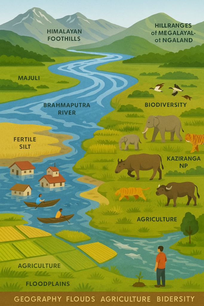
The Brahmaputra Valley is primarily identified with the wide and fertile plains of Assam, often referred to as the Assam Valley. This valley stretches like a long green corridor between the Himalayan foothills in the north and the hill ranges of Meghalaya and Nagaland in the south. The Brahmaputra River flows through the heart of this valley and acts as its central lifeline, around which villages, towns, farms and forests have developed over centuries.
One of the most striking features of the Brahmaputra Valley is its extensive flood plains. Every year, the Brahmaputra and its tributaries spread out over large areas during the monsoon season, depositing layers of fertile silt. Over time, this has created broad, flat and highly productive floodplains that support intensive agriculture and dense human settlements.
Example Product Title
👉 Buy on AmazonDisclosure: As an Amazon Associate, I earn from qualifying purchases.
The valley is also dotted with numerous river islands, the most famous being Majuli, which is considered one of the largest river islands in the world. In addition to Majuli, many smaller sandbars and temporary islands, locally known as chars, keep forming and disappearing due to the constant erosion and deposition by the river. This makes the geography of the Brahmaputra Valley highly dynamic, always changing with the flow and mood of the river.
Floods, Soil and Agriculture
The identity of the Brahmaputra Valley is deeply linked with its powerful and recurring flood cycles. Every year during the southwest monsoon, heavy rainfall in the hills and upper catchments causes the Brahmaputra and its tributaries to swell and overflow. As a result, large parts of Assam experience floods, leading to the submergence of villages, damage to roads and infrastructure, loss of crops and forced displacement of thousands of people and animals.
However, these floods also have a positive side. Along with the floodwaters, the river brings large quantities of fertile alluvial silt from the upper regions and deposits it over the farmlands. This natural process enriches the soil and helps maintain its productivity. Thanks to this fresh layer of silt, the Brahmaputra Valley is able to sustain abundant cultivation of rice, mustard, pulses, vegetables and other crops year after year.
This dual nature of the floods makes the Brahmaputra Valley unique. On one hand, the floods bring destruction and economic loss; on the other hand, they also bring renewal and fertility to the land. Because of this, agricultural practices, settlement patterns and even the lifestyle of the people living in the valley have gradually adapted to the rhythm of the river and its seasonal floods.
Biodiversity and National Parks
The Brahmaputra Valley is one of the richest regions of India in terms of biodiversity. The river, wetlands, floodplains, grasslands and surrounding forests together form a complex and vibrant ecosystem. Many rare and endangered species of animals and plants are found here, including the famous one-horned rhinoceros, Asian elephant, tiger, wild buffalo, various deer species, migratory birds and river dolphins (Gangetic/Brahmaputra dolphins).
To protect this biodiversity, several important national parks and wildlife sanctuaries have been established in the Brahmaputra Valley. The most renowned among them is Kaziranga National Park, a UNESCO World Heritage Site known worldwide for its population of one-horned rhinoceroses. Another key protected area is Manas National Park (located along the Manas River, a tributary of the Brahmaputra), which is both a Tiger Reserve and a World Heritage Site. In addition, numerous wetlands, beels (natural lakes) and riverine islands provide crucial habitats for birds and aquatic life.
This rich biodiversity not only enhances the natural beauty of the Brahmaputra Valley but is also deeply connected with the culture, livelihoods and traditional knowledge of the local communities. For this reason, environmental conservation, protection of forests and sustainable management of the river system are considered essential for the future of the valley and its people.
My Learnings: Life Lessons from the Brahmaputra
When I started looking at the Brahmaputra not just as a chapter in geography, but as a living, breathing river, I realised that it carries much more than water — it carries lessons about life. In its constant flow, its sudden changes of course, its calm stretches and its destructive floods, there is a reflection of the different phases of our own journey. The Brahmaputra silently teaches that change is natural, struggle is inevitable and movement is essential.
Sometimes the river appears peaceful and gentle, spreading life and fertility along its banks. At other times, it rises in fury, overflows its boundaries and forces everything around it to adapt. This dual nature reminds me that life too is a mix of comfort and challenge. We cannot expect only calm waters; we must also be prepared for storms. Like the Brahmaputra, we must keep flowing, finding new paths whenever obstacles block our way.
The people living along the Brahmaputra know that floods may come every year, yet they rebuild their homes, replant their fields and restart their lives with courage. From them — and from the river itself — I have learnt that hope must survive even in the middle of risk. True strength is not in never falling, but in rising again and again, just as the Brahmaputra returns each season with a renewed flow. It has taught me that if we move forward with patience, resilience and faith in our own efforts, our life, like the river, will continue to carve new channels of possibility.
Example Product Title
👉 Buy on AmazonDisclosure: As an Amazon Associate, I earn from qualifying purchases.
Environmental Challenges and the Future
Climate Change, Glacier Melt and the Risk of Floods
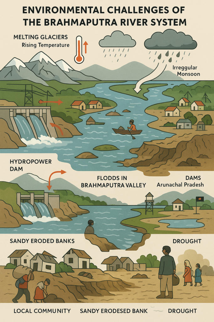
One of the most serious challenges facing the Brahmaputra River System today is climate change. Rising temperatures in the Himalayan region are causing glaciers, which feed the upper reaches of the Brahmaputra, to melt more rapidly. In the short term, this can lead to an increase in river discharge, but in the long term it may threaten the very stability of these glacial sources, as many of them are shrinking year by year.
At the same time, changes in rainfall patterns, irregular monsoon behaviour and an increase in extreme weather events are intensifying the risk of floods in the Brahmaputra Valley. Floods that were once more predictable and seasonal are now often heavier, more frequent and, at times, unseasonal. This not only damages agriculture and infrastructure, but also affects the overall social and economic stability of the entire region.
If the pace of climate change continues unchecked, the future may bring not only more frequent floods, but also periods of water stress and drought in some areas. Therefore, scientific water management, climate-resilient planning and greater regional cooperation are essential for the sustainable future of the Brahmaputra Basin.
Dams, Hydropower and Geopolitical Issues (India–China–Bangladesh)
The Brahmaputra is an international river that flows through China (Tibet), India and Bangladesh. Because of this, dams, hydropower projects and water-sharing arrangements on this river have important geopolitical implications. Large dams and diversion projects planned or built in the upper reaches of the river in Tibet have raised concerns in downstream countries like India and Bangladesh, particularly regarding the potential control or alteration of river flows in the future.
Within India too, several hydropower projects have been proposed or developed in Arunachal Pradesh and Assam. While these projects can help meet growing energy demands, they also raise questions about environmental impacts, seismic safety, the rights of local communities and changes in flood patterns downstream. If not planned and operated with transparency and strong environmental safeguards, such projects can create long-term ecological and social problems.
Since the Brahmaputra’s waters are the lifeline for millions of people in all three countries, transboundary water cooperation among India, China and Bangladesh is crucial. Regular dialogue, data sharing, joint flood-warning systems and common environmental standards can transform the Brahmaputra from a potential source of tension into a shared basis for cooperation and regional stability.
Local Communities, Livelihoods and Displacement
The people living along the banks of the Brahmaputra — farmers, fisherfolk, cattle herders and those settled on river islands (chars) and floodplains — are directly dependent on the river for their livelihoods. Their daily lives revolve around agriculture, fishing, river-based trade and seasonal activities that are closely tied to the rhythm of the river and its floods.
However, increasing floods, riverbank erosion and sand deposition are making their lives more uncertain every year. Whole villages sometimes get washed away or slowly eaten up by the river, forcing families to move repeatedly in search of stable land. This recurring displacement affects not only their homes and farms, but also children’s education, access to healthcare, employment opportunities and social security. People living on chars often struggle to secure land rights and consistent access to government schemes.
For a sustainable future, development planning in the Brahmaputra Valley must not focus only on big projects and urban centres. It must also place local communities, their rights, needs and traditional knowledge at the centre. Better rehabilitation policies, safer housing, flood-resistant infrastructure, alternative livelihood options and improved education and healthcare are essential to empower these communities. Protecting the people of the Brahmaputra is, in many ways, the most important step in protecting the future of the river itself.
Exam Corner: Brahmaputra River System for Students
Key Facts – In Short Notes Form
- Source (Origin): Near Chema-Yung-Dung on the northern slopes of the Himalayas in Tibet; in its upper course it is known as Yarlung Tsangpo.
- Total Length: About 2,900 kilometres (covering Tibet/China, India and Bangladesh).
- Countries Covered: China (Tibet), India and Bangladesh.
- Indian States Covered: Arunachal Pradesh (as Siang/Dihang), Assam (as Brahmaputra); further flows into Bangladesh as Jamuna.
- Different Names:
- Tibet – Yarlung Tsangpo
- Arunachal Pradesh – Siang/Dihang
- Assam – Brahmaputra
- Bangladesh – Jamuna
- Major Northern-Bank Tributaries: Siang/Dihang, Subansiri, Manas, Jia Bharali, Sankosh and others.
- Major Southern-Bank Tributaries: Buri Dihing, Dhansiri, Kopili and several smaller rivers from the hills of Meghalaya and Nagaland.
- Important Islands: Majuli – one of the largest river islands in the world; Umananda and other small river islands (chars).
- Valley: The Assam Valley – a fertile floodplain lying between the Himalayan foothills in the north and the hills of Meghalaya–Nagaland in the south.
- Nature of the River: Very high water discharge, braided channel pattern in many stretches, highly flood-prone, with rich alluvial soil on the floodplains.
- Major Projects (Broadly): Flood-control embankments and dykes, hydropower projects (especially on upper reaches and tributaries), irrigation schemes, and important bridges connecting the two banks of the river in Assam.
- Delta: In Bangladesh, it joins the Ganga (Padma) and Meghna to form one of the largest river deltas in the world.
Frequently Asked Questions (FAQ)
Where does the Brahmaputra River originate?
The Brahmaputra River originates on the northern slopes of the Himalayas near Chema-Yung-Dung in Tibet. In its upper course, it is called Yarlung Tsangpo. From there, it flows eastward across the Tibetan plateau before turning south into India.
What are the major tributaries of the Brahmaputra?
The major tributaries of the Brahmaputra can be divided into two groups – northern-bank tributaries and southern-bank tributaries:
- Northern-bank tributaries: Siang/Dihang (upper main course), Subansiri, Manas, Jia Bharali, Sankosh and several other rivers from Arunachal Pradesh and Bhutan.
- Southern-bank tributaries: Buri Dihing, Dhansiri, Kopili and many smaller rivers originating from the hills of Meghalaya and Nagaland.
Why is the Brahmaputra called a “male river”?
In Indian tradition, most rivers are considered feminine and are worshipped as goddesses. However, the Brahmaputra is often referred to as a “male river”. The reasons include:
- According to a popular mythological belief, the river is associated with a son of Lord Brahma, hence the name “Brahmaputra” (Brahma + Putra = Son of Brahma).
- The river is known for its enormous width, powerful flow and destructive floods, which symbolically represent strength and force, often described in masculine terms in cultural narratives.
Because of this mythological and cultural background, the Brahmaputra is uniquely identified as a “male river” in India.
What kind of questions are asked on the Brahmaputra in UPSC/SSC/State Exams?
In UPSC, SSC and various State-level competitive exams, questions on the Brahmaputra River generally test both factual knowledge and conceptual understanding, such as:
- Source and different names of the river (Yarlung Tsangpo, Siang/Dihang, Brahmaputra, Jamuna).
- Countries and Indian states through which the Brahmaputra flows.
- Lists and locations of major tributaries – Subansiri, Manas, Buri Dihing, Kopili etc.
- Questions related to Majuli – in which state it is located, in which river, and its significance as a large river island.
- Special features of the Brahmaputra – braided channel, high discharge, flood-prone nature, rich alluvial deposits.
- Its international importance in the context of India–China–Bangladesh, including issues of dams, hydropower and water sharing.
- Association with national parks – e.g., Kaziranga and Manas and their location in the Brahmaputra Basin.
Therefore, students should prepare the Brahmaputra River System in an integrated way, covering its origin, course, tributaries, geomorphological features, biodiversity, flood characteristics and international significance.
Conclusion: Life Messages from a Flowing River
Through this entire journey of understanding the Brahmaputra River System, I have realised that this river is not just a topic of geography; it is a deep metaphor for life. From its origin in the Himalayas to its vast delta, from its mighty tributaries to its fertile floodplains, from recurring floods to rich biodiversity and the lives of the people along its banks – everything about the Brahmaputra teaches us that life, too, flows, changes and evolves just like a river.
Sometimes the Brahmaputra flows gently, quietly nourishing the land and sustaining millions of lives. At other times, it rises with great force, reshaping fields, villages and even human plans. This contrast reminds us that joy and sorrow, ease and struggle, success and failure – all are natural parts of our journey. What truly matters is not how many challenges we face, but how well we learn to keep moving, balancing and growing in the middle of those challenges.
Today, as we stand at a crossroads of climate change, environmental crisis, floods, displacement and development pressures, the Brahmaputra offers us two powerful lessons – responsibility and hope. Responsibility towards nature, rivers and future generations; hope that even in difficult times, if we work together with wisdom, sensitivity and courage, we can find solutions. In this way, the Brahmaputra speaks silently to every generation: “Keep flowing, keep growing, and keep giving new meaning to life.”
References
- Official reports published by the Ministry of Jal Shakti, Government of India.
- NCERT Geography textbooks (Class 9–12) for foundational river system concepts.
- Government of Assam and Ministry of Development of North Eastern Region (DoNER) publications on the Brahmaputra Valley.
- Central Water Commission (CWC) annual reports on floods, water discharge and river basin studies.
- Research papers and studies published by UNESCO and WWF on the Brahmaputra River Basin.
- International reports related to transboundary water cooperation among India, China and Bangladesh.
